Foteviken during the Viking Age
The Viking Age around Foteviken
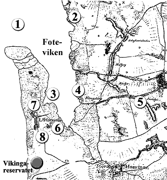
On this map from around 1811 you will find a number of interesting Viking Age sites marked.
-
The Foteviken barrier
North of number 1 on the map, two small islands are situated. They are called The Eskilstorp Islands or "The pillows". Theses are not marked out on the map from 1811. But on the oldest map preserved, dating back to 1687, drawn by Gerhard Buhrmann, these islands are clearly marked. However they were not islands in 1687, but a part of The Peninsula of Eskilstorp. The peninsula has disappeared under the surface of the sea since then, but these waters are still very shallow. The number 1 indicates the location of the Viking Age underwater barrier. It is located in the narrow mouth of The Bay of Foteviken. The mouth is only about 300 metres wide.
The barrier consists of thousands of rocks, each stone large enough for a man to carry. Within the barrier wooden poles have been driven down, along with the remains of four viking ships. A fifth ship has been excavated for conservation. A full scale copy of this ship, called the "Erik Emune", can be found within the Viking Town of Fotevikens Museum.
Construction of the barrier began during the time of king Harald Bluetooth during 980s AD acording to dendrochronology tests (tree-ring dating of the logs) of the wooden poles. The barrier was continually expanded up until the 1200s when it presumably no longer had a purpose.
The barrier was first described in print in 1967 by aerial archaeologist Esse Eriksson. Danish stone fishermen extracted a lot of rock from the barrier in the early 1900s to support construction in Copenhagen. In popular speech the barrier was called "the bridge" as it used to be traversable with horse and carriage while travelling to Malmö to sell fish. Though this fairly unlikely and can be attributed to folklore since the barrier has a clear channel for sailing in its center. On the hand drawn map of general governor Ascheberg from the 1680s the site is marked as "the stiga", i.e. a site with wooden poles.
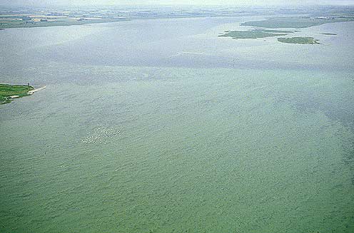 1986 aerial photo of the mouth of the bay of Foteviken. The deep trench can be seen in a darker blue color, though the underwater barrier is not clearly visible..
Today a narrow deep trench leads through the barrier into the bay of Foteviken. The bay is very shallow, in many places wade deep. The deep trench turns toward the south and follows the eastern beach of the Lilla Hammar isthmus. The area has treacherous underwater rocks making sailing into the bay of Foteviken difficult without a pilot.
Toward the center of the bay a small islet is located. It is likely manmade and may have been the site of an inner fortification before reaching the water basin that cuts inland like a small bay toward Lilla Hammar.
The bay of Foteviken has become a lot more shallow during recent years, as already pointed out by Esse Eriksson. He claimed that the deep trench may have been 2 - 3 meters deep. This is not necessarily the case though, since an additional half meter deep water compared to today is sufficient for viking age warships to sail into the natural harbor at Lilla Hammar.
-
Circular embankment of Eskilstorp
Situated to the northeast of The Bay of Foteviken and opposite of The Eskilstorp Islands, which are not marked on the map, is the circular embankment of Eskilstorp or rather the circular moat of Eskilstorp. It was the archaeologist Esse Eriksson, who discovered this ancient monument from the air, during the 1960-ies. He showed the aerial photographs to the professor of archaeology, Holger Arbman, who recalled that the monument looked like the stone built enclosed fields for stallion hunting found in central Sweden. "The Vikings used them for horse competitions and these enclosed fields had capacity for a large number of spectators".
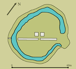 This drawing shows the circular embankment of Eskilstorp. The white fields indicate the shafts, investigated during the archaeological excavation in 1982. Torben Malm conducted this survey in 1982.
The moat features an oval formation, with a length of 50 metres and a width of 37 metres. The moat does not run all the way around the formation. There is a narrow opening, forming a free passage, situated at one of the long sides. The ground consists of sand and the width of the moat varies between 3 and 4 metres. In 1982 a minor archaeological excavation took place. A couple of minor shafts, located inside and outside of the moat, were investigated and excavated. Nothing was discovered, that could explain the function of this monument. Despite the results of this archaeological investigation, the hypothesis of the monument as an enclosed field for stallion hunting has been regarded as facts and a matter of course. It is rather fascinating how fast a minor casual thought is developed into an undisputable fact.
If this area is considered as a part of a major geographic context, it can be verified that the boundary between the hundred of Oxie in the north and the hundred of Skytt in the south extends to the coast exactly at this location. Some scientists are of the opinion that the hundreds originally might have been administrative regions that arise during the 11th century. Contrary to most hundred boundaries, the boundary between Oxie and Skytt does not follow a river or any other natural frontier. This boundary is a rather straight line stretching from the east to the west. This fact might indicate that this fertile and wealthy area, The Soederslaett, once has been divided into two more equivalent areas. In The Soederslaett area there are more early medieval churches situated, than anywhere else in Scandinavia.
The circular embankment of Eskilstorp is situated in the absolute vicinity of Foteviken and the fairway. The monument is located to the northeast of Foteviken and to the east of The Eskilstorp Islands. This means that this embankment has a very strategic location, when it comes to controlling the entire area and the mouth of Foteviken. As a landmark in this area it has probably facilitated the navigation in these treacherous waters. There might have been a Motte and Bailey (a fortified tower) situated inside the embankment and the moat might have been considerably wider than today. The sand material in the area and the constant floods can very fast and easily destroy the settlement, after it has been abandoned. If an archaeological excavation was carried out, investigating the moat, some answers might be found. It would be necessary to excavate a couple of shafts through the moat, in order to discover any remains from a fortified tower or any other type of constructions from the inside of the embankment. The embankment of Eskilstorp is really an interesting future archaeological site, well worth to investigate.
-
The harbor by Lilla Hammar village
Directly east of the old church hill (7), and north of the royal demesne (6) the bay of Foteviken forms a small bay into Lilla Hammar isthmus. This was likely the site harbor basin of the Viking Age Fotevik. Between (3) and (4) there is a small islet, not marked on the map, strangely located in the sand covered Foteviken. For this islet to even exist there must be stones or woodwork binding the sand. The islet forms a perfect base for an inner fortification of the harbor.
From the stone and wood barrier at (1) a deep trench goes directly along the eastern shore of the Hammar isthmus. This is the only likely fairway for the Viking Age ships. During approach it would have been impossible to sail, thus the ships must have been rowed. It takes roughly an hour to row from the barrier to the harbor basin. During the whole trip you would be so close to the beach that the ships easily could become targets of archers on land. The location of the harbor is thus perfect for defense. The Lilla Hammar isthmus also effectively shields from the harsh autumn and winter storms that almost always comes in from the west.
The deep trench through Foteviken bay is a continuation of the stream flowing into the southern tip of the bay, stretching past Stora Hammar church village, dewatering a large bog. This stream is gullied and a much smaller stream. Thus the old stream trench in the bay has silted as well. In the old days the deep trench must have been a lot deeper than it is today. The trench passes east of the small islet.
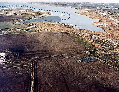 Aerial photograph of the Bay of Foteviken from the south. In the center of the bay the low islet is seen that may be a remnant of an inner fortification of the harbor basin.
 -
Fortification in Foteviken
On the map, dating back to 1811 there is an islet, in shape of a square, clearly visible at the name "Kongstorp"-Kings Thorpe. At this location a rivulet running from the area called Snekkebjär, number 5 on the map, falls into The Bay of Foteviken. This mouth forms the little square shaped islet, which is seen clearly on the map. This islet does not seem to be a natural formation. Since the ground in this area contains a lot of sand, the rivulet ought to run much straighter and not create almost right angles. This area has not been archaeologically investigated yet. The size of this islet is almost the same as another fortress, discovered at a place called Pile, situated at the coast, about 10 km to the north of this area.
-
Snekkebjär
Situated to the east of The Bay of Foteviken there is an oblong hill, called The Snekkebjär. Located at this place today, is an estate, called The Snäckeholm. The word "Snäcka" is the Viking Age word for warship. Danish scholars have discovered the remains of Viking Age shipyards at places, carrying names that include the word Snekke or Snäcka. It would be natural and possible that a shipyard could have been situated near Foteviken during the Viking Age. If the harbour has been used as a winter harbour for the Scanian war fleet, the warship would have required continuous repairs and maintenance.
-
The royal demesne
Located to the southwest of the village of Lilla Hammar, near The Bay of Foteviken is a large estate. This estate is solitary located outside the village and it is marked on all surviving maps of this area, even on the oldest map, dated 1687. The fact that it is solitary situated and not a part of the village settlement, is very interesting and it indicates that the owner of this estate must be important and have a special relationship to the village community. This estate is most likely to be the old royal State demesne at Foteviken.
The oldest indirect reference preserved, to a State demesne near the village of Lilla Hammar is found in one of the historical chronicles, depicting The Battle of Foteviken in 1134. The Danish king Niels had disembarked and landed with his troops, but he soon realized that he could not be victorious. He then received a horse from his servant or man, at Foteviken and king Niels managed to escape the battle and fled to one of his ships. This person might have been the royal bailiff at the State demesne at Foteviken.
King Niels arrived with the entire Danish war fleet. The Scanian war fleet did of course not participate in the attack and it was probably anchored in the harbour, in The Bay of Foteviken. The question about where the landing took place has been debated for a long time. When one studies this geographic area carefully, it is rather easy to find an answer.
The Danish troops probably disembarked and landed on the western coast of The Peninsula of Hammarsnaes. This means that the troops landed on the shore near the village of Lilla Hammar and the area where The Museum of Foteviken is situated today. The war fleet did not sail into The Bay of Foteviken through the deep fairway. The fairway is narrow and it is only possible for the ships to sail in a line into the bay and it would have taken far to much time to disembark the troops. It is not possible to land to the north of The Bay of Foteviken either. The coast to the north of Foteviken and all the way up to Malmoe is covered with large underwater stones and rocks. It is therefore not possible to successfully land at this part of the coast. The only possible place to land safely and disembark, is at stone free eastern shore of Hoellviken, that is the western shore of The Peninsula of Hammarsnaes.
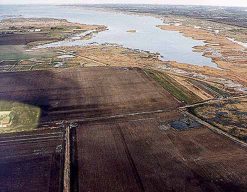 Aerial photograph of The Bay of Foteviken from the south. To the left, The Peninsula of Hammarsnaes and in the background the mouth of The Bay of Hoellviken are clearly visible. The village of Lilla Hammar is situated to the left just outside this photograph. The probable State demesne is marked in yellow.
There is also another important fact, which indicates that, the solitary estate near the village of Lilla Hammar is a State demesne. On the oldest surviving maps of the area, the estate has the same property number, as the site where the church in the village of Lilla Hammar was located. This church was demolished in 1584-1585. It is an interesting fact that these two geographically separate properties have had the same owner. The church in the village of Lilla Hammar was the personal property of the Danish king. The king also held the principal patron right of this church. This entitled the king to order the demolition of church in 1584. It also entitled the king to donate the building material, such as brick-stones and other material, to the hospital in the city of Malmoe.
The State demesne at Foteviken is still referred to, as late as in 1713. This very year an extensive reconnoitring was carried out, concerning the coast and shores between the city of Malmoe and the city of Ystad. The purpose of this reconnoitring was to ascertain possible place, where a hostile Danish army could land, in order to attack Sweden and Scania. The reference to Foteviken is interesting:
"From the village of Lilla Hammar to the State demesne, the bay is situated, and there after the coast is very long and full of stones and rocks and it is therefore inaccessible until the coast of the village of Limhamn."
-
Lilla Hammar village church
The medieval church of Lilla Hammar was situated directly to the north of the village settlement. This church was demolished in 1585. The Danish king ordered this demolition and donated the building material, such as brick-stones and other material, to the hospital in the city of Malmoe. This church was built of bricks and it is still possible today, to find broken brick-stones in the field, where the church once stood. It is very likely that this church built of bricks, was a successor of an earlier and older wooden church. The Museum of Foteviken plans for an archaeological excavation and investigation of the old church site in the future.
-
The pagan sacrificial grove
In the area to the south of the village of Lilla Hammar, there existed a field named "Lille Vies ager", this mean the field of the little pagan sacrificial grove. This field belonged to one of the village farms, which had been donated to the cathedral in Lund. The name of the field indicates that there might have existed a place or a field in the vicinity named "Store Vie", this means the field of the great pagan sacrificial grove. The field of Lille Vie is referred to in The Book of Lands of The Diocese of Lund, dating back to 1519. The possible location of Store Vie field is a lowland area and it is marked on the map of the 17th and 18th centuries as meadowland, which means a rather damp area.
A "Vi" was a pagan sacrificial grove, dating back to times before Christianity in Scandinavia. It has been established in Denmark that these pagan sacrificial groves, usually were situated near the coast and also had a possible close connection to the king. At Foteviken this theory squares well taking into account the probable State demesne, number 6 on the map.
The name "Vi" in connection with the village of Lilla Hammar is only referred to once, in The Book of Lands of The Diocese of Lund, dating back to 1519. This is the oldest document preserved, concerning the fields and lands of the village. The fact that this name has been preserved, according to tradition, might imply that it refers to an old established situation and settlement in the area, which has been lost.
A "Vi" area, situated near a State demesne, a harbour and the marketplace in the area, which is referred to before the year 1134, indicates that Foteviken during the prehistory and Viking Age probably was an area of great importance. A Vi, a pagan sacrificial grove or perhaps even a small pagan temple or sanctuary was probably situated in this area. It is rather interesting to notice that in the few sources preserved, referring to the pagan religious rites in Scandinavia, describe festival repasts, forming a major part of these religious rites. Remains of large feast halls have been discovered at Lejre on Zealand, in Denmark, near The Historical and Archaeological Experimental Centre of Lejre and in the village of Old Uppsala in Sweden.
Could such a festivity hall have existed at the "Vi", the pagan sacrificial grove at Foteviken? The Icelandic word "höll" means "hall" in Swedish. Perhaps this is why the bay to the west is named "The Bay of Höllviken", the bay at the hall. This is just one of the interesting questions about the area at The Bay of Foteviken and we hope to find some answers during future investigations and research.
